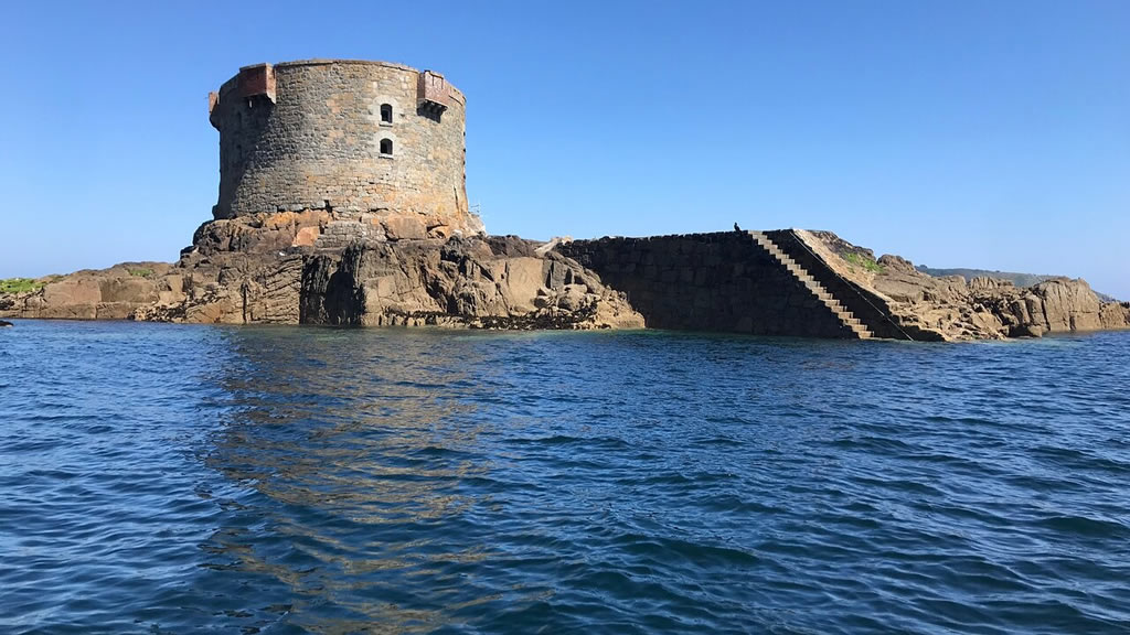
One mile northeast of St Peter Port and accessible only by boat lies an iconic oval structure made of Herm granite – Brehon Tower. It dominates the Little Russel between Guernsey and Herm and is so much a part of the local scenery that it can be taken for granted. But how did it come into being and what was its original purpose ?
Brehon Rock
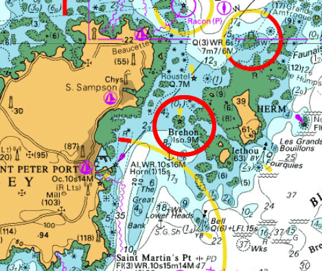 The Brehon rock is part of a reef that barely projects above sea level and has long been a shipping hazard.
It lies in the centre of the Little Russel channel that separates Guernsey from its nearest island neighbour, Herm. It dominates the entrance to the sheltered sanctuary of St Peter Port Harbour on the east coast of Guernsey.
An Ideal Defence Platform
Guernsey and Jersey, along with the other Channel Islands lived, for hundreds of years right on the front line of the seemingly endless wars between Britain and France.
In the 19th century the Brehon Rock became increasingly to be considered of primary importance to Guernsey’s defence against possible French invasion.
 As early as 1803 it was being considered as a defence point when Lieutenant-Colonel J McClean, R.E., reported to Sir John Doyle that a battery had been considered but was, at that time impractical to build. He went on to suggest that a Guard Room, which could also operate as a signal station be built on the rock at an estimated cost of no more than £100. – not an attractive proposition for the men who would have had to be stationed there! However it came to nothing.
In 1842 and again in 1847 the idea was revived again the shadow of an increased threat of French invasion and in response to the extension of fortifications in nearby Cherbourg.
The Construction of Brehon Tower
In 1854 the Crimean War broke out and Britain found itself in the rather novel position of being an ally of France against Czarist Russia, however relations between France and Britain remained guarded.

In 1854 the Crimean War broke out and Britain found itself in the rather novel position of being an ally of France against Czarist Russia
Fortification of the Channel Islands continued apace. Many of Alderney’s most prominent fortifications such as Forts Tourgis and Clonque were completed along with strengthening of sites in Guernsey, such as Forts Le Marchant, Richmond, Saumarez and Doyle at this time.
It was in this political climate that thought was given once again to protecting the Little Russel and a decision was made to fortify the Brehon Rock.
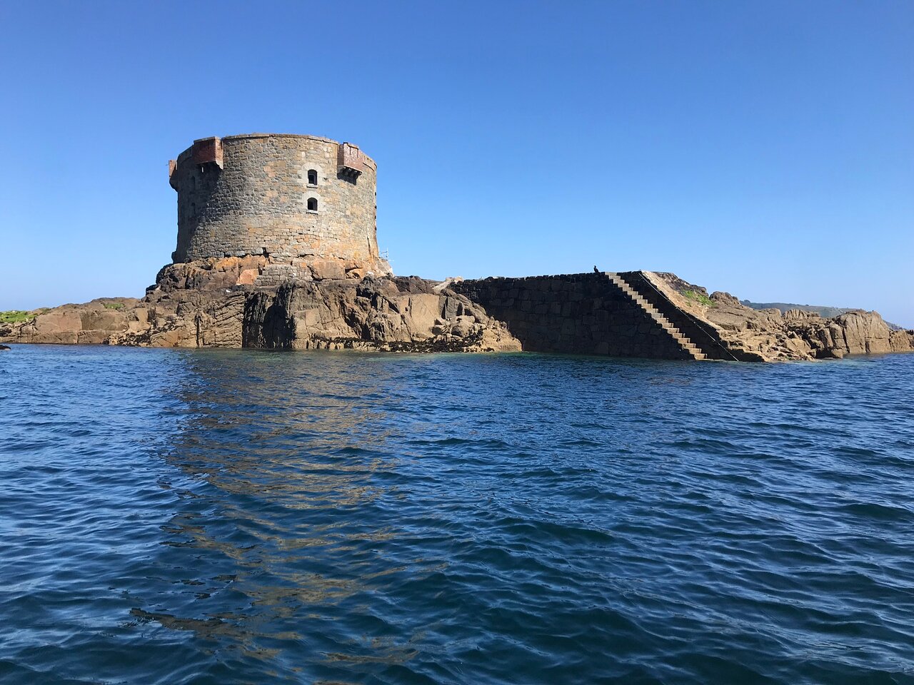
Access to the tower is by way of a landing stage and steps. The entrance to the tower is at 1st floor level on the southern side.,
There are two internal floors.
- On the ground floor is a 140 barrel magazine, shifting room, shell room, stores plus a 21,900 gallon sea water cistern.
- On the first floor are a number of rooms that were the living quarters for 2 officers and 35 men
A spiral stone staircase provides access to the flat roof where the original mountings were located for the cannon.
A small building on the roof contained the sidearms shed, expense magazines and a furnace for heating shot.
Powder and shot were raised through the tower by means of a small crane.
Tenders for the project were invited in the local press in May 1855 and work began the following August.
It is believed the tower was designed by a Captain in the Royal Engineers and built by Thomas Charles de Putron. Granite from Herm was used and it was finished in 1856 at a total cost of £8,098 18s. 10d. (about £480,000 today).
The walls are impressively thick no less than 2m at the base and typically over 1m thick at the top. Interestingly, the walls on the northern side are thicker and there are no openings on this side above the basement probably as this was considered the main direction of any attack.
Arming & Manning the Tower
It wasn’t until 3 years later in 1859 that the tower was armed when several 68 pounders guns were taken out to the tower.
The guns had a maximum range of over 3000m and were capable of firing a variety of shells : solid shot; explosive shells; grapeshot; case shot and molten iron shells (thin walled shells filled with molten iron).
A minimum crew of 9 men (usually commanded by a non-commissioned officer) was required to fire each gun.
Brehon Tower never saw active any service during the 19th century. By the end of the century, as the threat to the Channel Islands declined, the tower became obsolete and fell into disuse.
In 1914 the British Crown relinquished ownership of Brehon tower and it came into the hands of the States of Guernsey.
Active Service in the 20th Century
As testament to the enduring strategic position of the tower it was once again fortified by the Germans in WWII.
The occupying forces decided to use the tower as an anti-aircraft position. Alterations had to be made to accommodate modern weaponry and the roof was reinforced with steel beams so that a 10.5cm coastal defence gun could be added to protect the approaches to St Peter Port harbour. Two 2cm Flak guns were also mounted on the roof.
The internal accommodation was also made more comfortable for the small garrison by sub-dividing the larger rooms, insulating it better and adding stoves and portable heaters.
Brehon tower saw several actions during the war helping to shoot down allied air crew.
 22 May 1944
On 22 May 1944 four Spitfires of 610 Squadron took off from their base at Bolt Head, Devonshire, on an armed shipping reconnaissance near Guernsey. The 4 planes flying low down the Russel Channel fired on Bréhon Tower. Unfortunately 24 year old Flight Lieutenant Percy in his Mk XIV Spitfire was hit by anti-aircraft fire from the Tower.
Percy climbed to 1,500 feet and bailed out, but unfortunately his parachute failed to open, his aircraft glided down to the south and crashed into the sea off Jerbourg, Percy’s body was never recovered. His name is recorded on the Allied Aircrew memorial at Guernsey Airport.
- 5th June 1944
The flak emplacement on Brehon would also have taken part in a raid made on 5th June 1944 on the radar station at Fort George. It was the final periods of build up for the invasion of France, and on the eve of Operation Overlord, it became imperative to knock out the long range radar installations in the close vicinity of the Normandy beaches. Guernsey was one such location.

Freya Radar : Attacked on 5th June 1944 by Lt Saville
The RAF was tasked with knocking out of 2 such installations one called “Freya” and the giant “Würzburg” radar sites at Fort George.
On the 5th June 8 Typhoon Mark Ib’s, let by Flight Lieutenant John Saville took off from Hurn, Dorset, each carrying two 500 lb high capacity bombs.
In line astern formation they descended in a long dive from 11,000ft to 3,000ft in two bomb runs, first from the northeast, and then across the target in an easterly direction. All 16 of the bombs appeared to burst on or near the target itself, however the cost was high and the typhoons returned to base without Flight Lieutenant John Saville.
Unfortunately the radar wasn’t knocked out, and was able to confirm both aircraft and shipping movements on D-Day, to the German forces on the coast of Normandy.
Saville’s crash site was not located until the mid- 1960’s by Richard Keen, it is only 200 yards from Castle Cornet. It has subsequently been listed as an official war grave by the Canadian Government.
Today there is no public access to the tower but it still serves as a useful sea-mark and frequently as a home to flocks of the Common Tern.


