
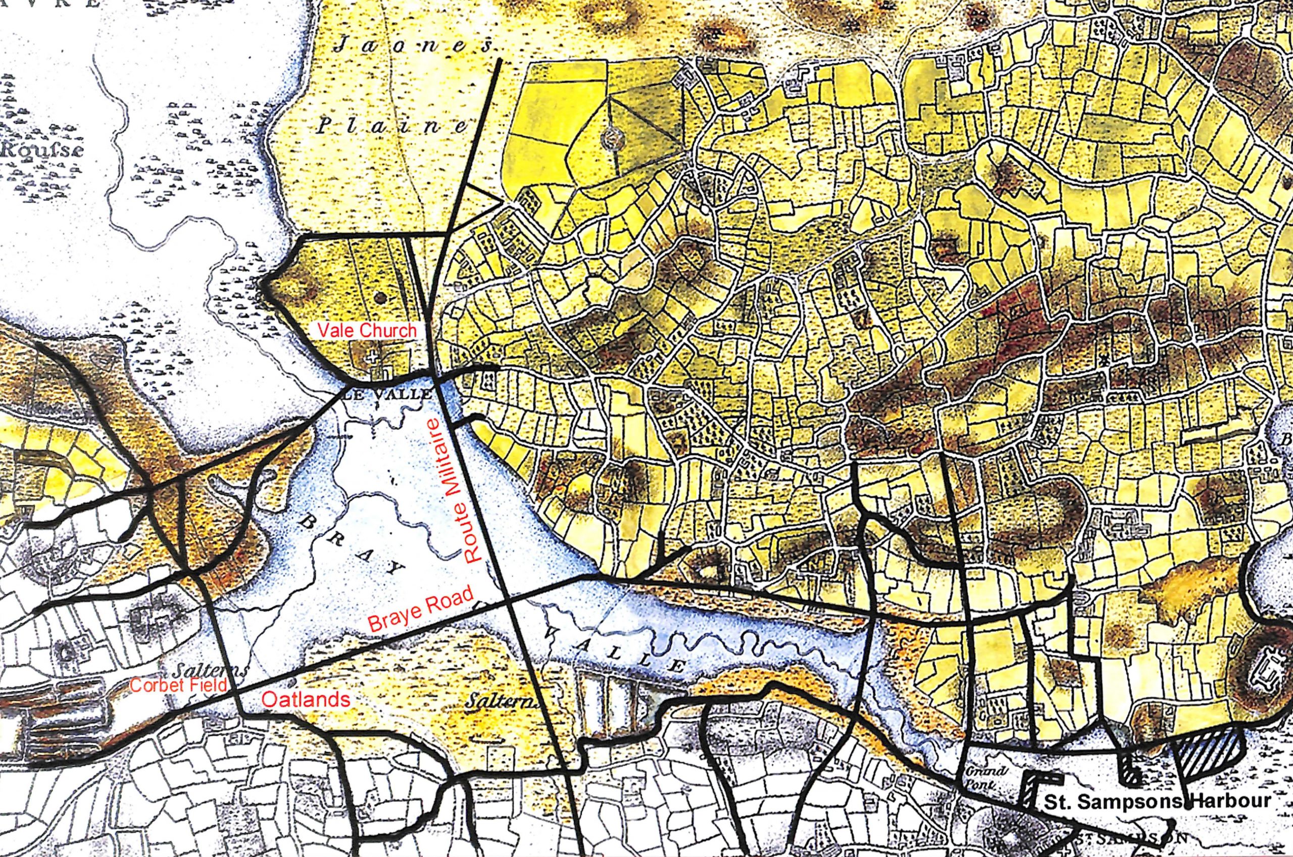
Before 1806 Guernsey was separated at high tide into 2 islands by a channel running across the island from the Vale church to modern day St. Sampson’s harbour.
The Braye du Valle is the name given originally to this shallow channel dividing the 2 islands . It wasn’t until 1806 that work began to reclaim the land and turn Guernsey into 1 island (You can read all about it in our article “When there were two Guernseys“)
But what was it like before it was filled in ?
Formation
No known records exist explaining how or when the Island was split in two by the creation of the Braye du Valle. However in a paper for La Societe Guernesiaise in 1935 Major S. Carey Curtis put forward the theory that seismic disturbances may have resulted in the lowering of the land mass which became the Braye du Valle. Certainly there were seismic disturbances in the Channel Islands in 842, 1091 and 1161.
The Braye du Valle might have always been low lying land. At the end of the fifth ice age, 10,000 years ago the sea levels started to rise and this little valley could well have been flooded by the ebb and flow of the tide.
In recent historical times, the Braye was never of any great depth, and was easily fordable at low tide.
The earliest mention of the separation of the Clos du Valle from the mainland is in a document dated 1204.
On 4th October 1204 an act of chief pleas was passed concerning the erection, of a bridge, now called “Le Grand Pont,” for the convenience of the inhabitants of the parishes of the Vale and St. Sampson. The act was passed by Bailiff Nicholas De Beauvoir and his jurats after complaints by parishoners that :
“they had been greatly impeded and damnified by the incursions of the sea, which had swept away and destroyed the convenient passage which existed between the said parishes, so that it was impossible to continue religious processions or traffic one with the other, and impracticable to go to the parish of the Grand Sarrassin“
Appearance Before the Reclamation
At various times several bridges existed across the Braye. The most notable and sturdy being at the St. Sampson’s end – where today’s St Sampson’s harbour and which of course is still known today as “The Bridge”
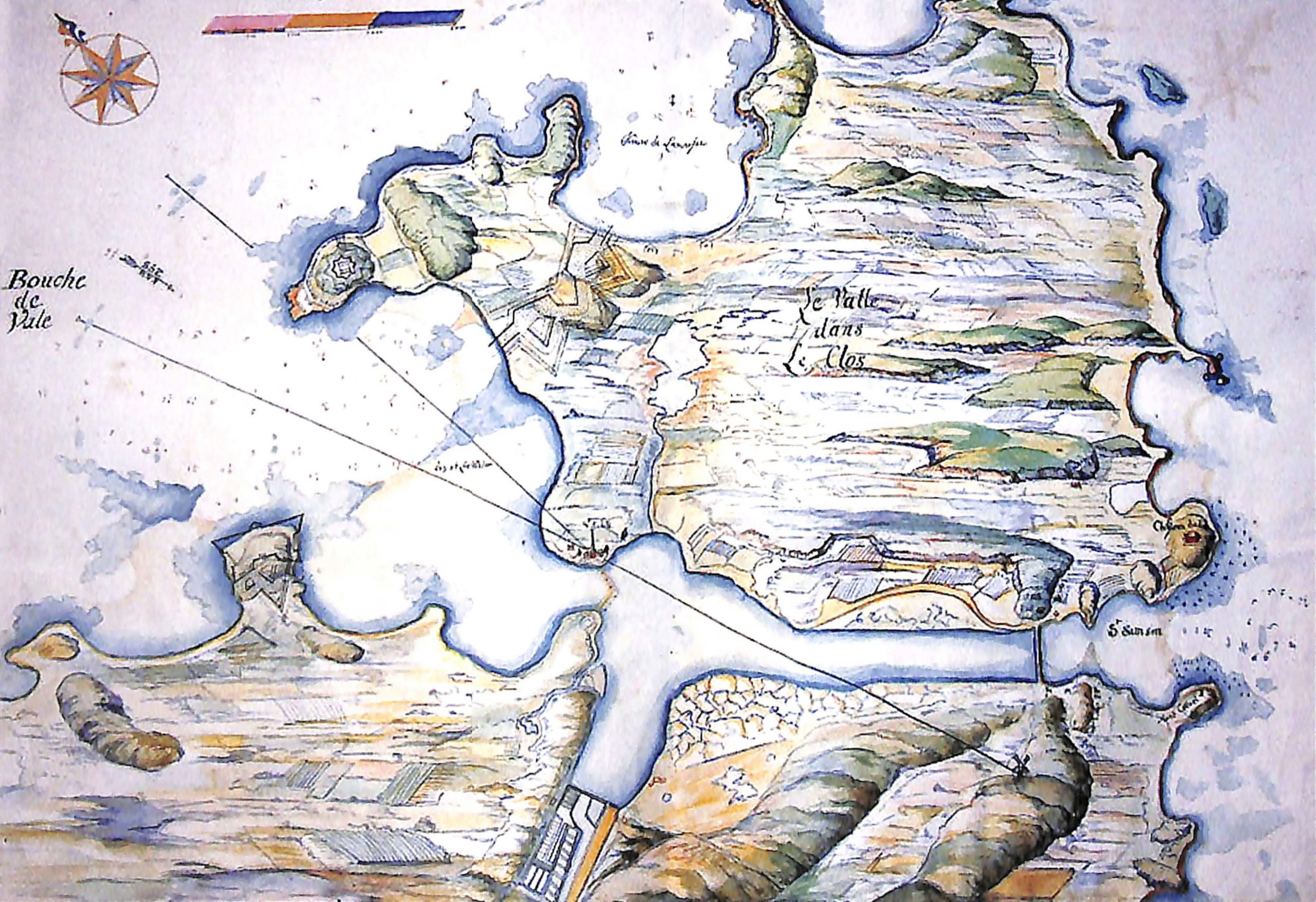
No reliable maps in medieval or Tudor times exist but we have several sources from which we can reconstruct what it may have looked like – and how it changed over time :
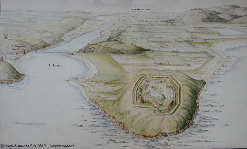
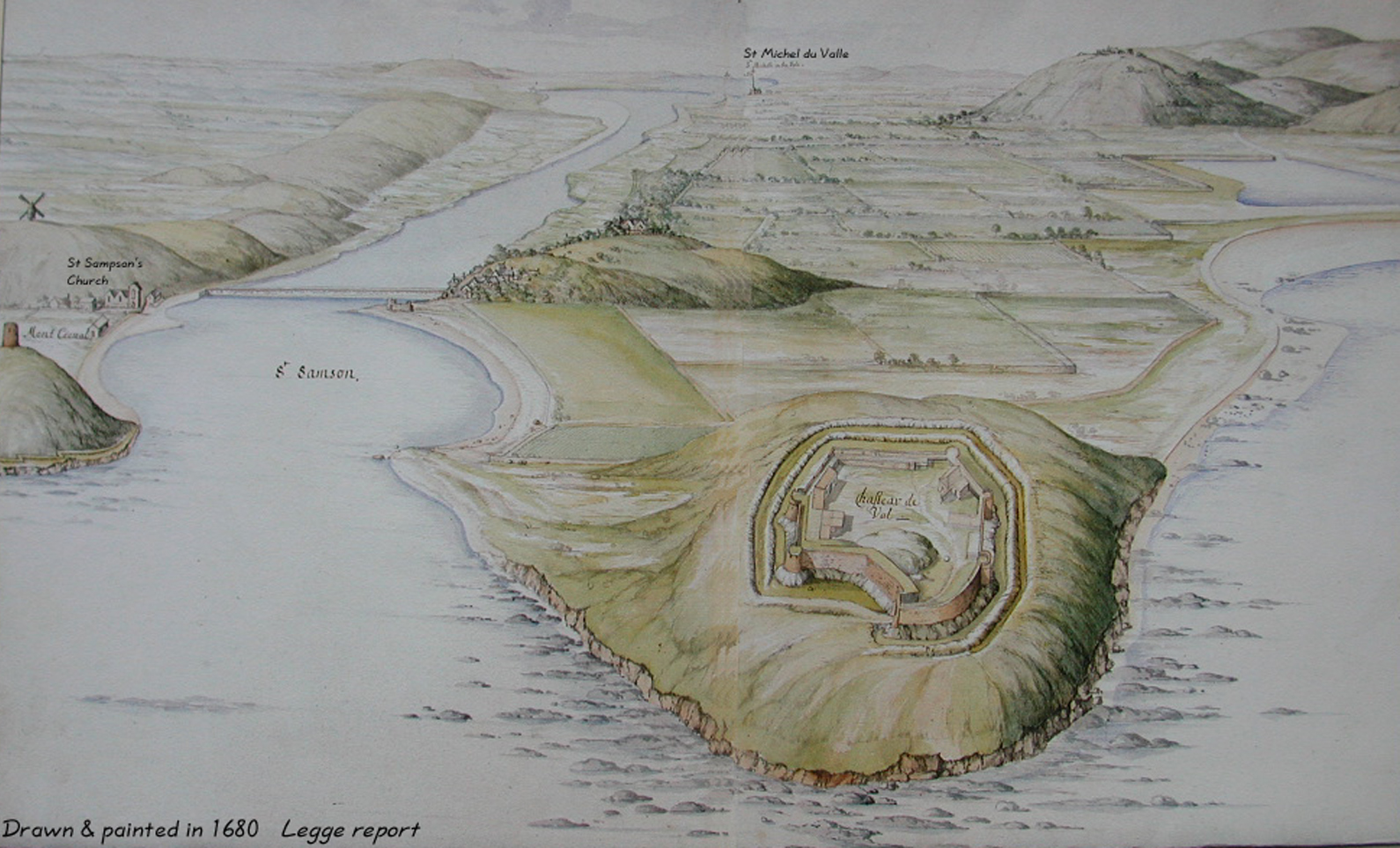
The Legge Report
Firstly we have various drawings & representations from the 1680 Legge Report – A survey of the defences of the island by Colonel Legge.

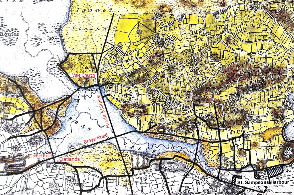
Duke of Richmond Map
Secondly we have an Ordnance Map made by order of the Duke of Richmond, then Master of the Ordnance for the island, in 1787, showing the Braye as it existed at that date. It is remarkably accurate in detail, so it is easy to construct, with the help of the modern Ordnance Maps, a plan of what we have today, suitably overlayed on to it.

F. C. Lukis
Lastly we have a valuable series of articles by the renowned Guernsey Victorian Antiquarian F. C. Lukis, where he describes the various changes which had taken place in Guernsey during his lifetime, among which is one of the Braye du Valle. He describes the Braye starting at Pont Colliche and moves in a clockwise direction describing each point of interest. Below we’ve included some selected extracts of his illuminating descriptions.

Lukis in his account illustrates that not all of them were “true bridges”, as they were covered at every tide:

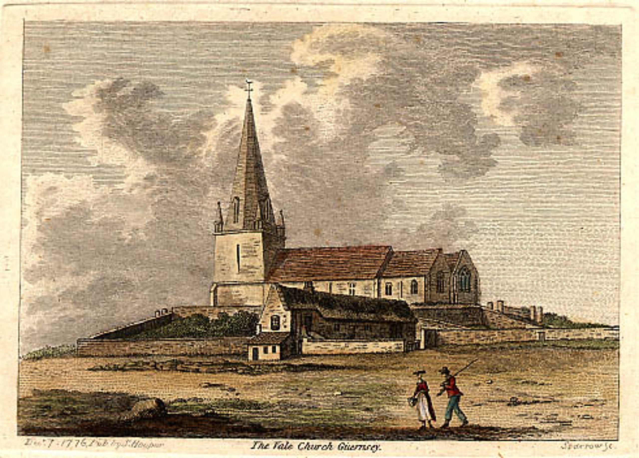
‘The stone bridge called the Pont Colliche was constructed of heavy rocky masses, and in the centre of its length, some very large flat granite blocks formed a sort of open bridge for the free passage of the sea during its rise and fall, as on the eastern side of the Vale the Bridge of St. Sampsons* was always fit for passengers and carts, but that of the ‘Pont Colliche’ was only capable of being used just before high water mark, and that only by foot passengers. This low bridge was built by the Monks of the Abbey of St. Michel, which once existed near the eastern angle of the present Vale Church, where at the present day several buttresses of the Abbey may be seen, near the ‘ Pont Allaire ‘, where the land stream passes beneath the large stones of the footway (now removed); the Vale Tavern being near it, a boat could always be obtained to cross to to the opposite side of the Braye, and on the western side of the shore, near the Salines, which were secured from the sea and its inroads by a strong embankment on which the road runs to the Vingtaine de l’Epine, you could likewise obtain a boat to cross or ferry to the Clos du Valle, near the Church.’
*modern day “The Bridge” – aka St Sampson’s Harbour
Lukis goes on to say :
“The Bridge at St. Sampson’s, was not then as we know it now, with a roadway wide enough for five or six lines of traffic. It was a simple bridge with a ‘Nocq’ or sluice running through it to allow the water at that end of the Braye to escape into St. Sampson ‘s Harbour.”
“Leaving St. Sampson’s and passing along Nocq Road, which again follows_ the line of the old Beach, we come to an interesting bit of the old Braye, the Saltings or Salterns, not to be confounded with the Saltpans. These were meadows which were overflowed by the sea at intervals, and a coarse kind of grass grew op them, which in England was in request for turning cattle into, in order to condition them. The salt lick in tropical countries is well known as the resort of big game which come down to brackish pools to satisfy the call of nature for salt ‘in their diet.”
“In the middle of these Salterns was a large salt-pan or rather series … They are now covered with an extensive series of greenhouses, put up a few years ago.”
“Next to these salt-pans was a large area of saltems, through which Route Militaire now runs, and is now known as Les Sauvages. The present Braye Road, runs along what was the old beach, the house of the Giffards, now called the Braye du Valle, having been built practically on what was the water’s edge.
Passing over these Salterns we come to the Grand Fort, which was an embankment forming the eastern boundary of the salt-pans …”
“In front of the Brookdale Nurseries where the road from Oatlands to L’Islet now is, was another track across the Braye, available when the tide served. This must have been an important one as it led across what is now L’Islet, and was then another salting and m the middle of which the L’Islet Dolmen stands, to the Pont Colliche, from which we started on our perambulation.”


You must be logged in to post a comment.